
Prefectural order
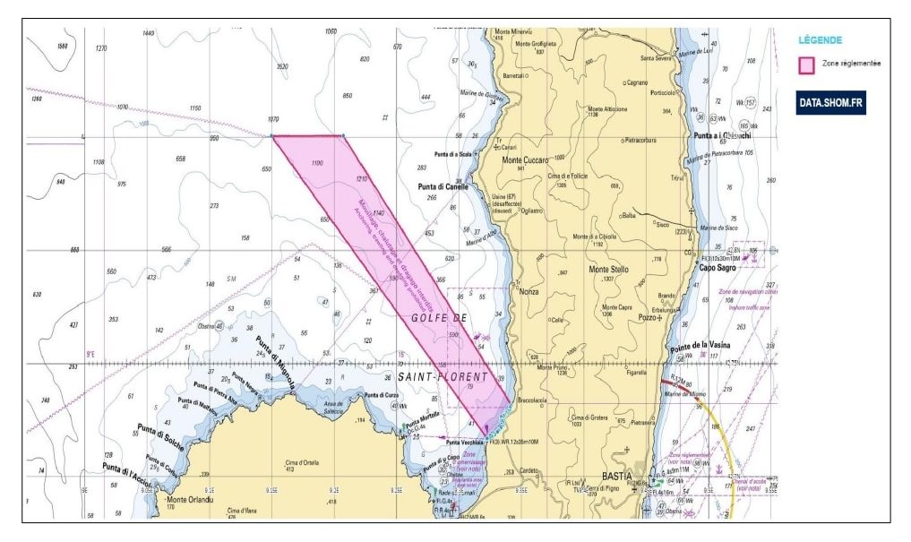
Prohibiting anchoring, dredging, and the use of trawl gear in the Gulf of Saint-Florent.
Anchoring of vessels with an overall length of more than 12 metres, dredging and the use of towed gear are prohibited within the delimited area:
- to the North, by the parallel 42° 51’ N; ;
- to the East, by the bearing of the Farinole Tower (42° 43.912’ N – 009° 20.565’ E) heading 140°; ;
- to the South, by the coastline; ;
- to the West, by the bearing of the Punta Vecchiaia lighthouse (42° 43.001’ N – 009° 19.367’ E) on a bearing of 137°.
Other documents
Order prohibiting exceptional harvesting of purple sea urchins
Order regulating the anchoring and stopping of vessels of 24 metres and over
Decision on the publication of the Roya beach marking plan
Port Bye-laws
Leisure Sea Fishing Information Sheet - Haute-Corse
Waste reception plan
Scuba diving regulations

The reef massif located on La Roya beach is part of a biotope protection zone described in the Order of 7 May 1998.
Forbidden practices
In the area defined in Article 1, the following practices are prohibited:
- circulation and anchoring of boats. However, this prohibition on entering the
zone does not apply to persons responsible for the supervision and management of
this area ; - abandonment, the deposit of refuse of any nature whatsoever. Any discharge, outflow,
direct or indirect deposit of polluting matter or liquid, or any act likely to affect
The quality of the environment is prohibited ; - the introduction and collection of marine plant species, whatever their stage
development, unless authorised for scientific purposes, by joint order of the
Minister for Nature Conservation and Minister for Maritime Fisheries; ; - spearfishing.
Biotope protection zone
A biotope protection zone is established on the maritime public domain situated within the perimeter delimited by the following points:
- Point A: 42° 40’ 56’’ North; 9° 17’ 35’’ East; ;
- Point B: 42° 40’ 63’’ North; 9° 17’ 36’’ East; ;
- Point C: 42° 40’ 78’’ North; 9° 17’ 45’’ East; ;
- Point D : 42o 40’ 78’’ North ; 9o 17’ 53’’ East ;
- Point E : 42° 40’ 58’’ North ; 9° 17’ 55’’ East ;
- Point F : 42° 40’ 56’’ N ; 9° 17’ 55’’ E.